Last weekend the class took a field trip to Point Reyes National Seashore see some examples of the concepts we discussed in class. Anyone who has looked at a map of the area and knows a little about geology may realize that the Point Reyes penninsula is very much an island. The San Andreas fault runs right through the Olema Valley and underneath Tomales bay - which I think is technically a large sag pond - creating the situation whereby the Pt. Reyes penninsula is on the Pacific plate moving slowly northward at a rate of a couple inches a year.
There were two concepts I really enjoyed learning on the trip, the first being the fact that the Bishop Pines are largely constricted to granitic soils and or bedrock. As I understand it the granites at Pt. Reyes were derived from the Sierran batholith by way of the Tehachapi mountains in Southern Ca. Nonetheless this fact really isolates the Bishop pine community and further emphasizes the island concept. It was good to see the amount of regeneration taking place and it sounded like the BP community was about due for a fire as they are fire adapted (the heat being neccessary to burst open the cones a germinate the seeds).
The other gem was Bolinas lagoon which is one of may favorite places anyway. Liam told us about his work there and I was intrigued by the sand lense that he has come across in many if not all of the corings from the lagoon. These layers of sand all occur on the same horizon and thus have the same date - sometime in the mid 1700's I think. Liam's major advisor Roger Byrne has posited that it may be from a tsunami that would have pushed over the sand spit at Seadrift. Apparently this event has been documented in other places. I'll be interested to the paper on this topic.
Monday, October 24, 2005
Wednesday, October 12, 2005
Geog 316 journal - The Island Foxes
 So I'm really excited because Liam just started the Island biogeography lectures, something I've been looking forward to since the beginning of class. I feel lucky that I work at a place where I get a chance to interact with people who know these concepts. Over the past 5 years I've done a few projects at Santa Cruz Island - a change detection analysis, some cartography, and database design for the pig eradication project.
The topic that has dominated Santa Cruz Island is the Island Fox. I've been so caught up in the drama of the pig eradication that I always took the natural history for granted. And when Liam mentioned that Lori blogged about the foxes I was compelled to do my own research.
Google scholar searches showed the consensus to be that the grey fox rafted to the northern Channel Islands (NCI), probably during a storm event. But it seems crazy, what did they eat? Apparently they are omnivorous and will eat berries as well as mice. The populations of the southern Channel Islands were brought by the Chumash people as they were far more isolated.
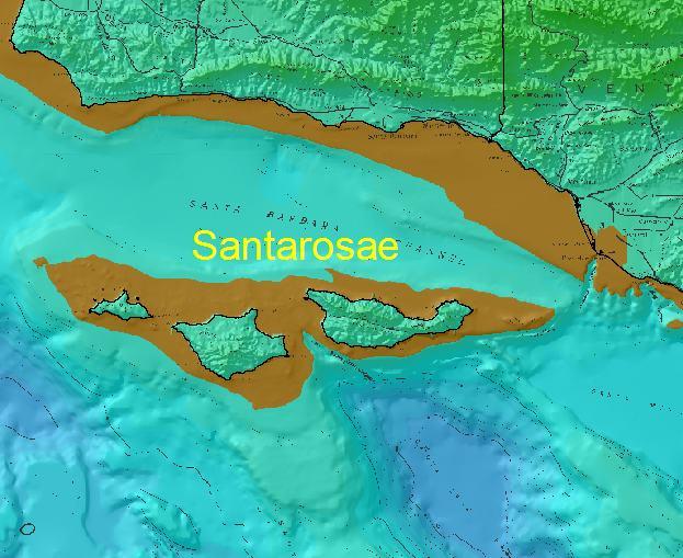
Fox fossil remains at Santa Rosa Island date to 10,400-16,000 years ago and during that time (the end of the Pleistocene) sea level was much lower connecting all the NCI's into one large island called Santarosae. We learned in class that sea level was about 100m lower on average. So I took my research one step further by doing a quick GIS analysis using a digital elevation model. I wanted to see how far these foxes had to raft in these conditions. I colored up the DEM so that the 0-100m contour highlighted the ancient shoreline (map above). As it turns out they would only have to raft 7 miles from the mouth of the Santa Clara River. This seems more plausible than the idea that the slender salamander came down from the north coast on a redwood tree....but that's a whole other entry.
Thursday, October 06, 2005
Geog 316 journal - Prioritizing Global Biomes
For the last two weeks we've been talking about global biomes in class and the timing is uncanny given the efforts of international conservation NGO's, TNC included. "The 2015 goal" as it's been called seeks to conserve 10 percent of all biomes on earth. Now this might seem ambitious but you have to consider that some global biomes have a decent amount of protection - maybe somewhere in the range of 20-30% which is considered by some enough to maintain ecosystem viability over the long term. But in order to determine where you go next require prioritization beyond just what is underrepresented by protected areas.
The major biome types that Liam discussed in class have been applied wholesale to WWF Ecoregions. For example the entirety of the California central coast ecoregion is classified as Mediterranean forests and woodland and Mojave desert would be considered deserts and xeric shrublands. These biomes are then aggregated in realms i.e. Nearartic This type of GIS representation has its issues - MAUP for example, but there's a real need for spatial explicitness.
In order to prioritize amongst these biomes there are four considerations: biological significance, habitat condition, biodiversity risk, and enabling conditions. Each of these elements has a whole list of assumptions and input data sets. For example biological significance is based on the WildFinder database (lists number and species by taxa per ecoregion ), wide ranging intact large mammal assemblages, and areas with mammal migrations. The initial model combines all four of the above elements to rank ecoregions and thus biomes. This is a really hard thing to do because no one wants to admit that the ecoregion they may be responsible for is not worth conserving.
My role in this effort has been to take a deeper look at just the Mediterranean biome types. The idea being the global assessment identifies med biomes as high priority so now what? If conservation has a dollar to spend, where do you put it? Europe is impacted and so is Southern California. But Baja and South Africa may provide viable alternatives. I spent all day today discussing a framework for this decision making that builds on the global effort but makes considerations specific for med type biomes. Like fragmentation for example. Our text mentions that speciation in the med basin of Europe may be driven by a high degree of fragmentation. So how do you tweak the dial on the habitat condition component to account for this?
At this point there are more questions than answers. I'm looking forward to getting more familiar with these med geographies, South Africa, Australia, Europe, Chile. The best part is congruence between school and work, it makes me secure in the relevancy of geography as a discipline.
Subscribe to:
Posts (Atom)