This weekend friends of ours invited us to go camping and kayaking on Tomales Bay. We stayed at Lawson's Landing on Saturday night. Lawson's is interesting, it's right at the mouth of Tomales bay was likely a spit similar to Limantour or Seadrift, judging by the amount of dunes around. Most of the dunes had been taken over by european beachgrass, but I thought I had spotted some natives but my plant identification skills are novice. I say was a spit because it has been developed into a fairly large campground and the tip, Lawson's Landing itself, has been bulkheaded so the littoral drift and natural transport of sand has been altered. When we arrived on Saturday afternoon the tide was ebb exposing large mudflats.
There was quite an assemblege of birds picking around, likely feeding on invertebrates in the mud. There was distinct spatial separation to the feeding that corresponded with body type. The longer legged birds (like curlews, and herons) could move out further while the lighter smaller birds (sanderlings) could stay on the squisher mud with out sinking in. What was interesting was when the tide came in, the entire system was compacted into a mucThis weekend friends of ours invited us to go camping and kayaking on Tomales Bay. We stayed at Lawson's Landing on Saturday night. Lawson's is interesting, it's right at the mouth of Tomales bay was likely a spit similar to Limantour or Seadrift, judging by the amount of dunes around. Most of the dunes had been taken over by european beachgrass, but I thought I had spotted some natives but my plant identification skills are novice. I say was a spit because it has been developed into a fairly large campground and the tip, Lawson's Landing itself, has been bulkheaded so the littoral drift and natural transport of sand has been altered.
When we arrived on Saturday afternoon the tide was ebb exposing large mudflats. There was quite an assemblege of birds picking around, likely feeding on invertebrates in the mud. There was distinct spatial separation to the feeding that corresponded with body type. The longer legged birds (like curlews, and herons) could move out further while the lighter smaller birds (sanderlings) could stay on the squisher mud with out sinking in. What was interesting was when the tide came in, the entire system was compacted into a much narrower zone and there was not nearly the same diversity of birds that were there at low tide.
We paddled from Lawson's straight across the bay to Avalis beach. Along that western shore there's nice variety of nearshore habitat. I tried to stay close to shore, within the photic zone. As the shoreline changed from sandy to rocky, eelgrass beds started to show up and with them sea stars and smaller fish like jack smelt. It was easy to see how these areas serve as nurseries for fish in their early lifestage. I was even lucky enought to see a tiger shark and a ray. I could on and on about the simple pleasures of floating in a kayak and pondering biogeography.....look for more later.
Monday, November 21, 2005
Monday, October 24, 2005
Geog 316 journal - Point Reyes
Last weekend the class took a field trip to Point Reyes National Seashore see some examples of the concepts we discussed in class. Anyone who has looked at a map of the area and knows a little about geology may realize that the Point Reyes penninsula is very much an island. The San Andreas fault runs right through the Olema Valley and underneath Tomales bay - which I think is technically a large sag pond - creating the situation whereby the Pt. Reyes penninsula is on the Pacific plate moving slowly northward at a rate of a couple inches a year.
There were two concepts I really enjoyed learning on the trip, the first being the fact that the Bishop Pines are largely constricted to granitic soils and or bedrock. As I understand it the granites at Pt. Reyes were derived from the Sierran batholith by way of the Tehachapi mountains in Southern Ca. Nonetheless this fact really isolates the Bishop pine community and further emphasizes the island concept. It was good to see the amount of regeneration taking place and it sounded like the BP community was about due for a fire as they are fire adapted (the heat being neccessary to burst open the cones a germinate the seeds).
The other gem was Bolinas lagoon which is one of may favorite places anyway. Liam told us about his work there and I was intrigued by the sand lense that he has come across in many if not all of the corings from the lagoon. These layers of sand all occur on the same horizon and thus have the same date - sometime in the mid 1700's I think. Liam's major advisor Roger Byrne has posited that it may be from a tsunami that would have pushed over the sand spit at Seadrift. Apparently this event has been documented in other places. I'll be interested to the paper on this topic.
Wednesday, October 12, 2005
Geog 316 journal - The Island Foxes
 So I'm really excited because Liam just started the Island biogeography lectures, something I've been looking forward to since the beginning of class. I feel lucky that I work at a place where I get a chance to interact with people who know these concepts. Over the past 5 years I've done a few projects at Santa Cruz Island - a change detection analysis, some cartography, and database design for the pig eradication project.
The topic that has dominated Santa Cruz Island is the Island Fox. I've been so caught up in the drama of the pig eradication that I always took the natural history for granted. And when Liam mentioned that Lori blogged about the foxes I was compelled to do my own research.
Google scholar searches showed the consensus to be that the grey fox rafted to the northern Channel Islands (NCI), probably during a storm event. But it seems crazy, what did they eat? Apparently they are omnivorous and will eat berries as well as mice. The populations of the southern Channel Islands were brought by the Chumash people as they were far more isolated.
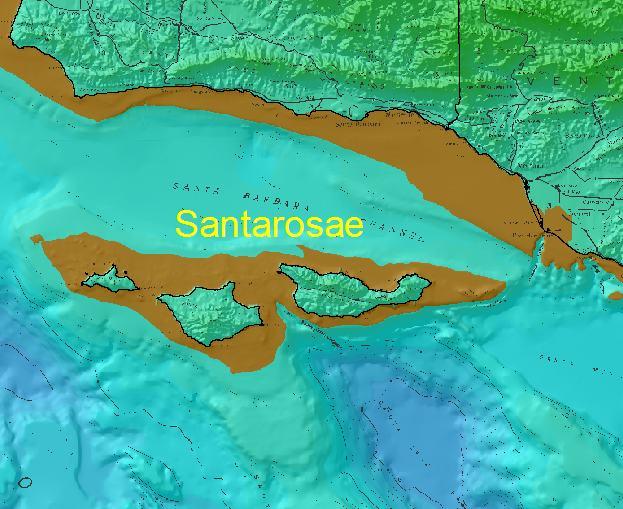
Fox fossil remains at Santa Rosa Island date to 10,400-16,000 years ago and during that time (the end of the Pleistocene) sea level was much lower connecting all the NCI's into one large island called Santarosae. We learned in class that sea level was about 100m lower on average. So I took my research one step further by doing a quick GIS analysis using a digital elevation model. I wanted to see how far these foxes had to raft in these conditions. I colored up the DEM so that the 0-100m contour highlighted the ancient shoreline (map above). As it turns out they would only have to raft 7 miles from the mouth of the Santa Clara River. This seems more plausible than the idea that the slender salamander came down from the north coast on a redwood tree....but that's a whole other entry.
Thursday, October 06, 2005
Geog 316 journal - Prioritizing Global Biomes
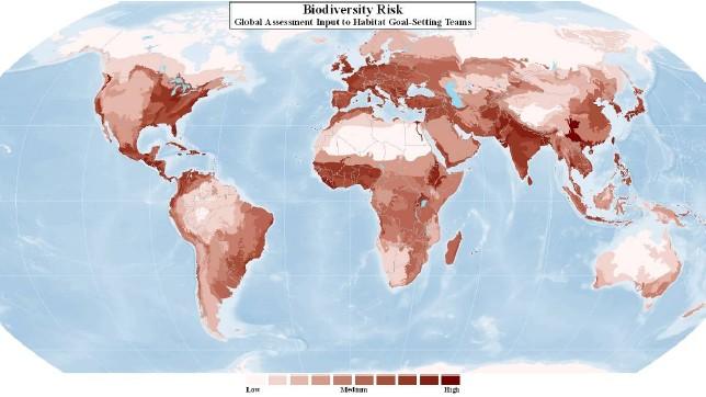
For the last two weeks we've been talking about global biomes in class and the timing is uncanny given the efforts of international conservation NGO's, TNC included. "The 2015 goal" as it's been called seeks to conserve 10 percent of all biomes on earth. Now this might seem ambitious but you have to consider that some global biomes have a decent amount of protection - maybe somewhere in the range of 20-30% which is considered by some enough to maintain ecosystem viability over the long term. But in order to determine where you go next require prioritization beyond just what is underrepresented by protected areas.
The major biome types that Liam discussed in class have been applied wholesale to WWF Ecoregions. For example the entirety of the California central coast ecoregion is classified as Mediterranean forests and woodland and Mojave desert would be considered deserts and xeric shrublands. These biomes are then aggregated in realms i.e. Nearartic This type of GIS representation has its issues - MAUP for example, but there's a real need for spatial explicitness.
In order to prioritize amongst these biomes there are four considerations: biological significance, habitat condition, biodiversity risk, and enabling conditions. Each of these elements has a whole list of assumptions and input data sets. For example biological significance is based on the WildFinder database (lists number and species by taxa per ecoregion ), wide ranging intact large mammal assemblages, and areas with mammal migrations. The initial model combines all four of the above elements to rank ecoregions and thus biomes. This is a really hard thing to do because no one wants to admit that the ecoregion they may be responsible for is not worth conserving.
My role in this effort has been to take a deeper look at just the Mediterranean biome types. The idea being the global assessment identifies med biomes as high priority so now what? If conservation has a dollar to spend, where do you put it? Europe is impacted and so is Southern California. But Baja and South Africa may provide viable alternatives. I spent all day today discussing a framework for this decision making that builds on the global effort but makes considerations specific for med type biomes. Like fragmentation for example. Our text mentions that speciation in the med basin of Europe may be driven by a high degree of fragmentation. So how do you tweak the dial on the habitat condition component to account for this?
At this point there are more questions than answers. I'm looking forward to getting more familiar with these med geographies, South Africa, Australia, Europe, Chile. The best part is congruence between school and work, it makes me secure in the relevancy of geography as a discipline.
Tuesday, September 20, 2005
Geog 316 journal - Disturbance at Steep Ravine

Jill and I spent last Friday night at the Steep Ravine cabins in Mt Tamalpais State Park. From the title you probably think this is about the mouse that ate all our hot chocolate but alas I'm going to ponder the coastal bluff scrub. So if you've been to Steep Ravine you know that the cabins are actually on an old alluvial deposit and to the north and south are steep cliffs. I noticed a lot of what I think is coastal bluff scrub (cbs) clinging to cliffsides and was wondering at what point of succession is this community.
It's apparent that there's a lot of mass wasting happening here and with that a clearing of the vegetation. So is cbs the expression of a primary successional phase? If so this is complicated by the fact that cbs is fairly limited in California - likely an endemic. So is this physical barrier of cliffside erosion contributing to the endemism of cbs? And what if the coastal erosion stopped, would cbs be succeeded by something else? Or is cbs the climax community? Overall I think the Gleason model is probably more appropriate for this community.
Just a quick note about invasive, on a fresh slide just to the north the pampas grass was doing a great job at getting established. It would easy to imagine the cbs being overtaken by this plant in the not so distant future.
Tuesday, September 13, 2005
Geog 316 journal - Coastal salt marsh gradients

When you study geography in California you inevitably come across the Sierra Nevada transect. The typical graphic will show the elevation gradient from west to east and the associated tree species often delimited by elevation. It's a great driving reference as the changes in tree types occur at a scale that may be otherwise imperceptible on foot.
So when Liam drew the example of a salinity gradient in a salt marsh I was captivated. Apparently plant communities in a salt marsh will vary depending upon how much salt is in the soil. From salty to fresh, plant communities will create a continuum of mud flat to salt marsh to sedges to cattails. I take the ferry to Larkspur whose landing is flanked on the north by some pretty good examples at Corte Madera Marsh. The great thing about a salt marsh is that the gradients happen at a smaller ecological scale and you can actually see to whole mosaic with advantage of some elevation.
I biked over and I have to say the patterns were not readily apparent. I was still in that Sierra Nevada mindset - I was thinking elevationally. The plant communities were not falling out that way though, the mosaic was more a complicated patchwork. I moved on. On my ride home I pass another little piece of salt marsh along Corte Madera creek. This one is far smaller but the gradient was immediately recognizable. The salinity barriers were being driven by the drainage network in the marsh. The meandering streams had banks of taller sedges, while the interior areas furthest from the streams (more dessication, more salt) had the salt marsh community (pickleweed and chordgrass).
I've stopped at this marsh to breathe in the relief that nature brings hundreds of times, but this time I saw it differently. Now I like it even more.
Thursday, September 08, 2005
Geog 316 journal - Environmental Gradients
So last weekend I actually stole some plants from the grocery store behind my house. I know I know but hey there plants and this a big grocery store, and besides they just left them out overnight out back....so I think they wanted people to take them. Anyway that's not the point. When I started putting these guys into the ground (basil and vinca) I couldn't help but notice the little tag that highlighted the best growing conditions. This immediately got me thinking about environmental gradients.
Apparently the basil thrived in full light conditions. And this sends me into thinking about scale and the distribution of products. The tag didn't need to say only grow these plants in temperate dry summer / wet winter climates - those climatic barriers are implicit to the sale of plants in our region. But they did say plant in full sunlight - thus taking advantage of a microclimate in your own back yard. So I planted mine in a semi sunny spot, let's see how they do at the edge of their range.
Apparently the basil thrived in full light conditions. And this sends me into thinking about scale and the distribution of products. The tag didn't need to say only grow these plants in temperate dry summer / wet winter climates - those climatic barriers are implicit to the sale of plants in our region. But they did say plant in full sunlight - thus taking advantage of a microclimate in your own back yard. So I planted mine in a semi sunny spot, let's see how they do at the edge of their range.
Sunday, August 28, 2005
The Devils Teeth
My partner and I Jill finally made it out to the coast yesterday, what a gorgeous day! It's looking like the fog is easing up a bit, but I doubt the drought is. The bouys were suggesting a bit of a south swell with a nice long period, oddly Point Reyes wasn't picking it up. I went by way of bike (bofax - alpine dam - seven siters - pantoll - stinson -whew) and Jill met me there. It was a great place to finish The Devil's Teeth, I could almost see the Faralones offshore. Poor Peter Pyle...he ended taking the fall for this piece of journalism, it's really too bad. But I will be interested in following the work of Barbara Block's Lab and the TOPP program - they ended up with the permits. Talk about marine biogeography - these guys are getting some really cool data. After seeing a talk by Pat Halpin from Duke, I got really interested in looking at these type of data against marine physiographic data (salinity, chlorophyll, sst) - too bad that stuff is so f'ing hard to process. Anyway DT was great in a Outside Magazine kinda way - just the right mix of natural history and personal interest for a great summer read.
Geog 316 journal - Why take a class in biogeography?
 Well that's really the question right? It was for me at least, I've spent the last 10 years putting off an advanced degree mostly because it was the path of least resistance. I've been lucky enough to be really working as a geographer - GIS mostly. Now that I'm back in the academic mix I keep thinking "what was I waiting for?" Biogeography is extremely relevant for me right now. Managing all the GIS support for TNC in CA calls on the fundamentals quite a bit.
For the better part of the last two years I've been the GIS analyst supporting a number of marine planning projects. These are done at a the ecoregional scale and for California that means the California Current. So biogeograpy is concerned with the distribution of species through space and time....this notion is the crux of representative conservation planning. While for some taxa there are good GIS data sets available, for most there are not, this particullarly true for marine. In cases where there are not data available they can be modeled. This is where biogeography comes in. The better I can understand the relationships taxa have to their spatial environment, the better the GIS models to use a surrogates for conservation.
Thursday, August 25, 2005
Geog 316 journal - The Fog and The Drought
So there was some talk in the first meeting about fog and fog dynamics and I couldn't help but start to think about what a cool summer it's been on the coast. I regularly check the NRL satellite for fog at the coast and this summer seems the coast seems to have had more foggy days that "normal" (n=15yrs of amatuer observations). Now this is just a feeling, no hard data, but it got me wondering why. Given that bay area fog is generally driven by central valley warming and thus the creation of localized low pressure - (warm air rising in the valley creates a vacuum and thus the marine layer is sucked eastward) - I couldn't help but wonder if the midwestern drought has anything to do with our more than "normal" foggy days at the coast - particularly since they've lasted well into August which is generally clear. My simple thinking is this, the mid and pacific northwest are likely to be warmer than average thus creating this vacuum effect but at a little larger scale than just the bay area / central valley dynamic. Strictly anecdotal science at this point but maybe an idea worth pursuing.
Geography 316 - SFSU
Just went to the first meeting of Geography 316 - Biogeography at San Francisco State University yesterday. The instructor Liam Reidy gave a short overview of the broad topics we will cover in class. I was a little nervous about getting back into the academic fold (currently enrolled as a Master's student in Geography) but this class eased my fears. The topics were highly relevant (biodiversity, island biogeography) to my line of work which makes it that much better. I'm going to attempt to use this blog for weekly journal entries required for this class. Those posts will have Geo 316 journal as headings. Look for more soon!
Subscribe to:
Comments (Atom)